


Using NASA’s SMAP satellite to detect L-band interference

by Nuke’s
So here’s the deal: I didn’t expect NASA’s SMAP satellite — built to measure soil moisture — to end up doing open-source ELINT. But it is. And it’s wild.
Radio&Nukes Substack is a reader-supported publication. To receive new posts and support my work, consider becoming a free or paid subscriber.
Between January and early May 2025, I started pulling SMAP’s public L1B brightness temperature data and noticed something weird. Some areas were screaming hot in the 1.4 GHz band — way too hot to be natural.
That frequency’s supposed to be quiet. It’s a protected slice of the spectrum. Nobody’s allowed to transmit there. So when the brightness temperature spikes past 360K, something’s up. Usually something military.
I mapped it.
🛰️ Detected: Unauthorized Emissions
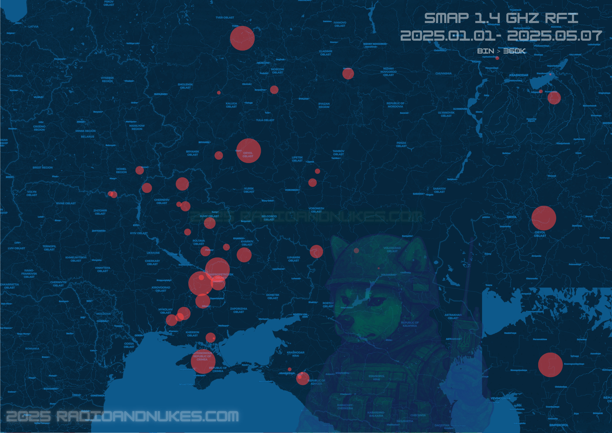
Each red blob is a spot where SMAP picked up strong radio frequency interference — most likely jamming, spoofing, or some kind of high-power EW emission.
It’s not random. It lines up almost perfectly with:
Russian EW sites
Ukrainian drone corridors
Front-line staging areas
and a couple interesting outliers in the rear
What Is SMAP Actually Doing?
Normally, SMAP floats around the planet passively listening for blackbody radiation at 1.41 GHz — L-band. It gives us soil moisture and ocean salinity. But when you shove a few hundred watts of RF into that band, SMAP notices.
And it doesn't even have to try.
The brightness temperature in a clean spot is like 270–310 K. Over a desert? Maybe 330. But once you're hitting 360, 370, even 375 K? That’s not the sun. That’s a jammer.
Why Jam L-Band?
The 1.4 GHz band isn’t just reserved for peaceful Earth observation — it’s also adjacent to some very useful real-world military signals.
Jamming in or near this range can disrupt:
Drone command and control links (especially custom or modded systems)
Video feeds from FPV drones
GNSS signals and spoofable harmonics
Satellite telemetry and downlinks
Passive radar or sensing systems
In a modern conflict zone, jamming L-band means blinding drones, degrading targeting, and cutting off ISR. It’s not accidental. It’s deliberate.
The international treaties that say “don’t transmit here”? Those don’t matter much when you’re trying to survive a drone swarm.
Welcome to the Jam Zone!!
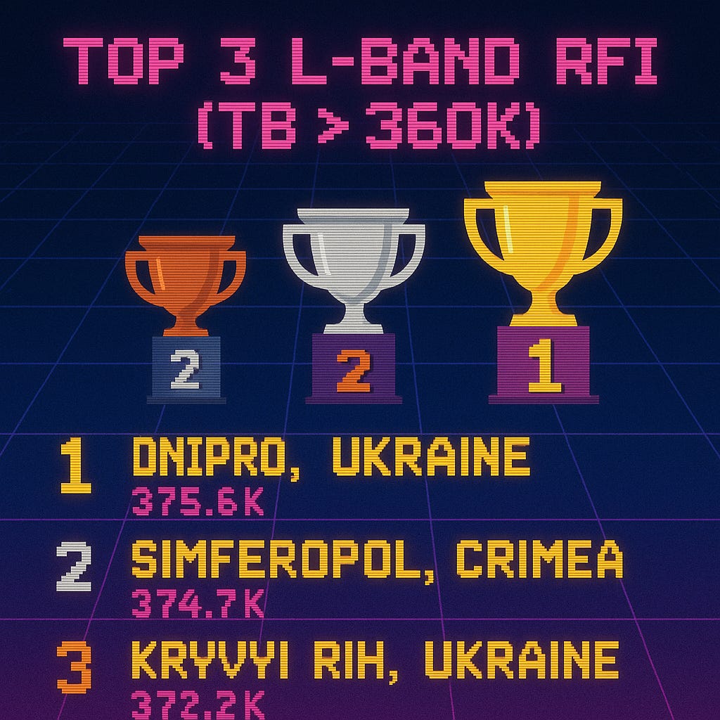
SMAP doesn’t play games, but if it did, Dnipro, Simferopol, and Kryvyi Rih just topped the leaderboard. These three lit up the L-band with brightness temps well over 370K — way beyond natural levels — putting them squarely in the high score zone for RFI. No need for captions when the spectrum speaks for itself.
Why This Matters
This is all open source. I didn’t use a drone, didn’t hack a satellite feed, didn’t bribe any operators. Just a climate satellite, some Python, and a bit of time.
And the result? A map of electromagnetic warfare happening in real time over Ukraine, Crimea, and parts of Russia.
—
🛰️ Data source: NASA SMAP L1B_TB
📦 Code + data: github.com/radioandnukes/SMAP-RFI-Mapper
🧠 Made by: Nuke’s
🌐 radioandnukes.com
Radio&Nukes Substack is a reader-supported publication. To receive new posts and support my work, consider becoming a free or paid subscriber.
What's Your Reaction?
 Like
0
Like
0
 Dislike
0
Dislike
0
 Love
0
Love
0
 Funny
0
Funny
0
 Angry
0
Angry
0
 Sad
0
Sad
0
 Wow
0
Wow
0